Hazard Mitigation Planning

iStock/antonyspencer
According to the fourth National Climate Assessment, "at-risk communities in the Midwest are becoming more vulnerable to climate change impacts such as flooding, drought, and increases in urban heat islands. Tribal nations are especially vulnerable because of their reliance on threatened natural resources for their cultural, subsistence, and economic needs."
The Plans
Since 2010, U-Spatial, the University of Minnesota’s center for geospatial advancement, has contracted with Minnesota counties and tribal governments to create multi-jurisdictional Hazard Mitigation Plans (HMPs). While updating an HMP is a requirement for federal hazard mitigation grant funding programs, the process is also a powerful frontline tool for climate resilience. Bringing together planners, emergency managers, and community members, the HMP process identifies risks and vulnerabilities, develops a plan of action built on capabilities and partnerships, breaks the cycle of disaster & reconstruction, and builds stronger & more resilient communities.
U-Spatial has developed a first-in-the-nation interactive county-level HMP: each county receives an ArcGIS Hub Site primed for broad understanding and public engagement. The websites include infographics, charts, and interactive map data that is customized for each county, allowing residents to explore local vulnerabilities to natural hazards with dynamic data from NOAA databases, FEMA National Risk Index, USGS gauging stations, and local event stories. Pages are dedicated to mitigation actions - the on-the-ground work of community resilience - and climate change, with a focus on how a warming climate exacerbates natural disasters. Finally, online surveys allow for community engagement in the HMP process with ongoing, interactive opportunities to submit feedback from anywhere with an internet connection.
These efforts provide a more visible foundation of up-to-date and engaging information for the county to access between planning cycles, as well as provide U-Spatial, State of Minnesota, and county stakeholders content for future planning and communications.
U-Spatial’s expertise in geospatial analysis and emergency management planning, less-resourced counties can be on even footing with their larger counterparts to engage the public while designing mitigation strategies based on sound risk assessment.
To get started, contact Stacey Stark ([email protected]).
Why Plan?
Research by the National Institute of Building Sciences has shown that for every dollar spent on hazard mitigation, an average of $6 is saved.
U-Spatial conducts the hazard risk assessment for 1% annual chance floods using the Hazus GIS tool. This tool enables communities of all sizes to predict estimated losses from floods and to measure the impact of various mitigation practices that might help reduce those losses. The Minnesota Homeland Security and Emergency Management (HSEM) office has determined that Hazus should play a critical role in Minnesota’s risk assessments, and therefore the 1 percent annual chance flood hazard analysis was introduced in the 2010 plans. U-Spatial has also utilized Hazus for every Minnesota State Hazard Mitigation Plan since 2010.
Our Experience
U-Spatial has developed hazard mitigation plan updates for counties and tribal governments across Minnesota, in addition to various Hazus flood hazard analyses. U-Spatial staff have expertise in geospatial analysis and emergency management planning, and develop plans that engage key stakeholders while designing mitigation strategies based on sound risk assessment.
For our county-level hazard mitigation plans, we contract with Hundrieser Consulting for community outreach.
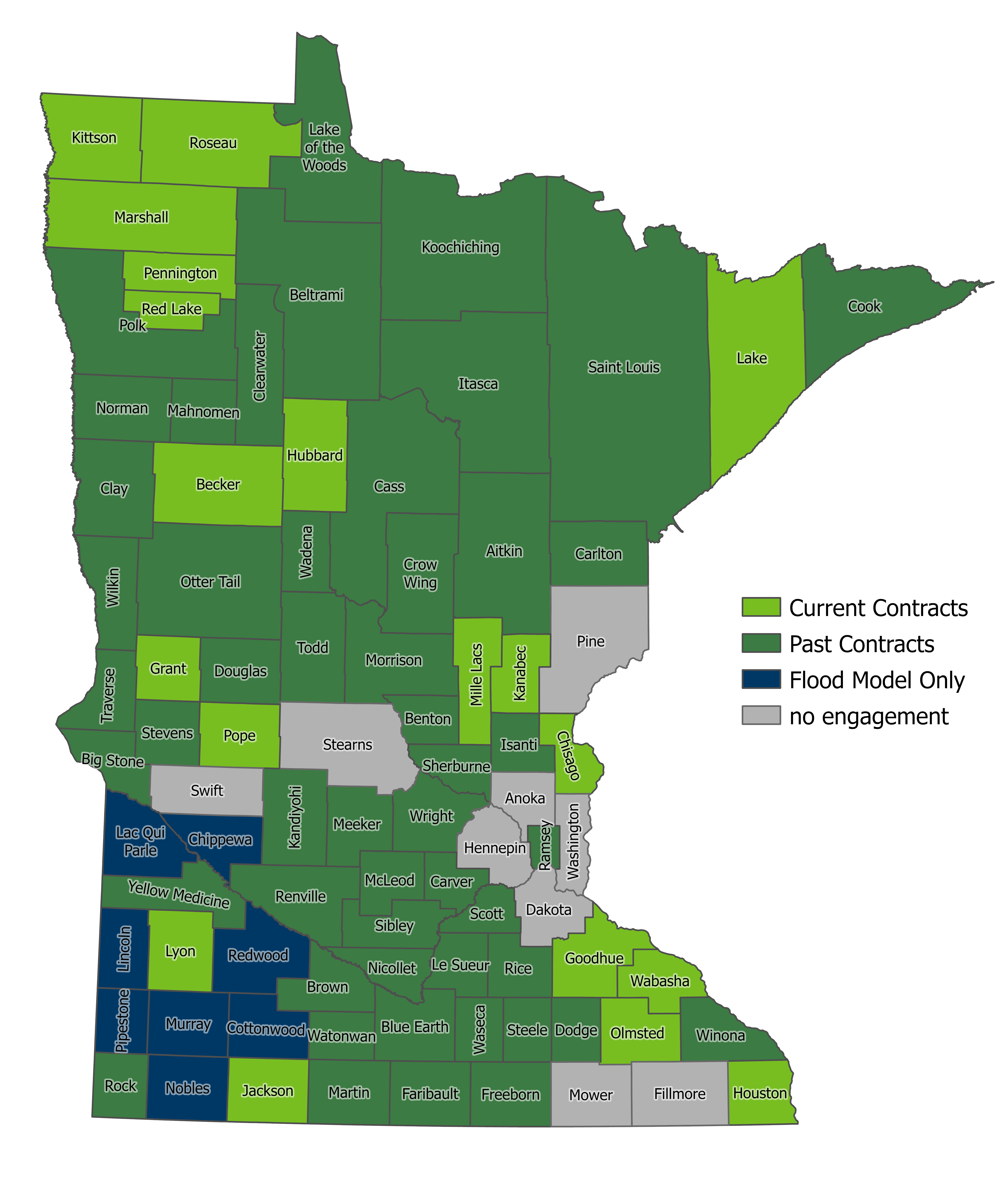
Map depicting the extent of U-Spatial's hazard mitigation planning work throughout the state.